Nashville International Airport (BNA)
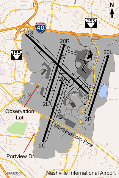
The Nashville airport has an official observation area located next to the cargo terminals on the west side of the field, at the end of Vultee Blvd. Its easily accessible, safe, and free but Nashville doesn’t get that much traffic. You can see the entire airport but only traffic on runway 2L/20R is close to the observation area.
There is another spot on the south side called Portview Drive. To get here, go east on Murfreesboro Pike to McGavock Pike and make a right, and then go a few blocks. Portview and the streets surrounding it were once a residential neighborhood but many of the houses have been bought out and removed due to noise issues from being so close to a runway. You can park along this street (not on the grass) and watch planes approaching BNA’s center runway. Photography from either one of these spots is best in the afternoon as you’ll be facing east.
The largest airlines here are Southwest, American, and Delta. There are also flights from Frontier, JetBlue, and several regional airlines. Aircraft are mostly the Boeing 737, Airbus 320, and Regional Jet types. The only regular international flights are on Air Canada Express to Toronto using regional jets and seasonal flights on Aeromexico to Cancun. There is a military facility at the Nashville airport – the 118th Airlift Wing which flies the C-130. There is also some cargo activity here, mostly in the early morning hours. Despite losing its daily China Airlines Boeing 747 flight, Nashville still has daily flights from FedEx and ABX. Embraer has a regional jet service support facility here and occasionally there are Embraer jets from other countries operating here.
Examples of Photos
