San Francisco International Airport (SFO)
Click the map to go to Google Maps satellite view of this airport
San Francisco International is a major airport that has many options for watching and photographing airplane traffic. It is a very busy airport serving most major domestic and international airlines with steady traffic all day; the largest airline here is United as this is one of their hubs. The airport is located on the west side of the bay so any photography would be best in the afternoon and from fall to spring. You will find that during the summer there is significant heat distortion that will ruin most photos of aircraft on the ground.
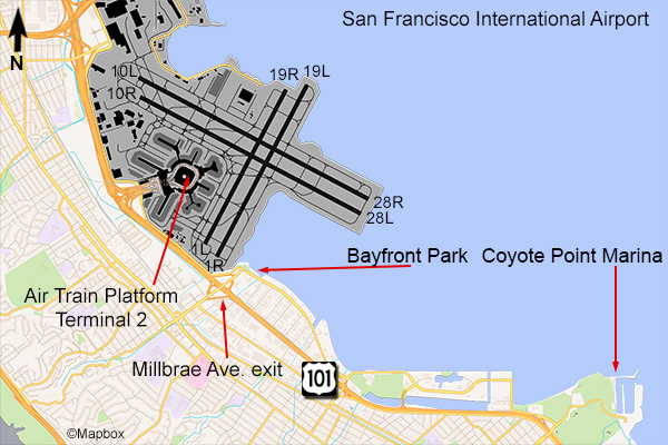
The first spot is the Terminal 2 Air Train station. SFO has a rail line going from the car rental garage to all the terminals & parking. Terminal 2’s station is the one with the best view. At each end of the platform by the elevator there is an open air balcony. From the north end balcony you will have a view of runways 28L & 28R and the taxiway between Terminal 2 and Concourse E. You won’t be able to see down the runway to the east, but you’ll be opposite the rotation point and can see aircraft climb out to the west. From the balcony on the south end, you’ll see runways 1L & 1R which are used for domestic airline departures as well as aircraft taxiing to that runway or Concourses A, B, and C of Terminal 1 including Southwest, Alaska, and Delta. You will not need a long zoom lens at this location although it can be helpful for certain shots and for the many Skywest Airlines regional jets. I noticed that the heat distortion was less when shooting from the south end of the platform. Follow the links below for some sample photos from each end of the train platform.
The next location at the San Francisco airport is the famous one that everyone visits to photograph SFO traffic: Bayfront Park. Exit the 101 Freeway at Millbrae Ave. go east 1 block to Old Bayshore Hwy and turn right. The park will be on the left. There is a very limited amount of free parking because people come here to walk the trails or just take in some fresh air by the bay but I didn’t have to wait too long for a space. This park is directly opposite the approach end of runways 28L & 28R at about a mile out into the bay. You will have an unobstructed view of landings and aircraft taxiing for takeoff. This is a very popular spot for photos because all of the international airlines at SFO use these runways and you won’t need more than 400mm zoom for the larger planes. The heat distortion here can be very bad during the summer though. Follow the links below for some pictures from Bayfront Park.
The third spot and best one for approaches is at Coyote Point Marina. This is located further south than Bayfront Park and a little further out in the San Francisco bay which will allow a better, closer view of aircraft on final approach to runways 28L &28R. You will not need a long zoom lens here, and heat distortion is minimal. Take the 101 freeway south from Millbrae for 3 miles to exit 417, Poplar Ave. You’ll have to make a right on one of the streets and head back north a bit to Peninsula Ave since there isn’t an exit from southbound 101 to Peninsula. Make a right on Peninsula and take it to the marina. There will be an entrance fee of $5 which is waived after 6pm. Follow Coyote Point Drive to the parking area at the end. This will be your best view of landing aircraft. Follow the links below for some pictures of aircraft from this location.
Also, there is a new Sky Terrace in Terminal 2, pre-security, that offers a great view of the ramp and runways 28L & 28R. There is no cost to visit this spot.


