Cincinnati – Northern Kentucky International Airport (CVG)
Click the map to go to Google Maps satellite view of this airport
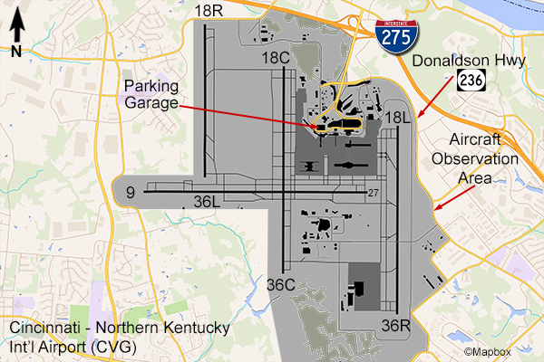
The Cincinnati Airport is located across the river from the city in the state of Kentucky. There is an “official” Aircraft Observation Area located on Donaldson Hwy. on the east side of the field. It is basically a gravel lot slightly elevated from the runway. It offers a good view of runway 18L/36R and is hassle-free by the authorities. It is very popular and was crowded with people when I was there. If you drive north on Donaldson Hwy. to where it goes around the end of the runway you may be able to pull over to watch some landings but you may be told by police to go back to the Observation Area.
Most traffic patterns here are north-south and you can get a good enough view to photograph the aircraft that operate on this runway. The most common airlines here are Delta and Frontier along with their regional partners. Other cities are served by United Express and American Eagle. Delta and Air Canada Express handle most of the international flights here. Since this is the home of DHL there is a significant cargo operation with carriers such as FedEx, Airborne Express, DHL, Polar, and Kalitta.
It is possible to watch and photograph planes from the east side of the parking garage roof, which is close to the east runway, but this is not officially sanctioned by airport security so you may be asked to leave if spotted. On the garage you’ll be facing east so the light is best a couple hours before sunset but morning is best for the Observation Area since it faces west. The Cincinnati Airport has 3 other runways so it can be a gamble as to whether this runway will be in use.

